
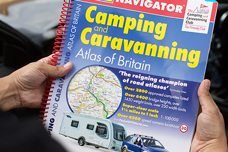
Bus, Cycle and Activity Mapping

Activity and Transport Mapping must differentiate between routes and options available to the user
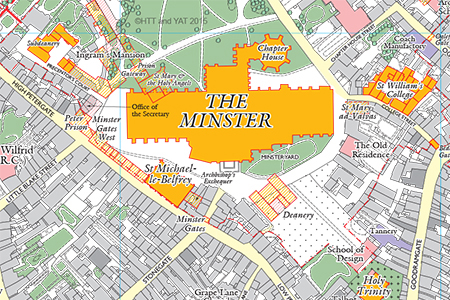
Atlas and Educational Mapping
Our experience in Atlas Mapping means we consider every aspect of a map project
Industries

Take a look at the maps and mapping solutions we offer to these market sectors, among several others
Our Reviews
The Lovell Johns team was professional, knowledge, and responsive. They delivered a user-friendly and engaging map within a tight schedule that has been received well by EC BID
Sefinat Otaru, Cross River Partnership
We couldn’t have had a smoother consultation and generation of the maps for this title: Lovell Johns gave us great guidance and accommodated our particular needs for this very particular book
Mick Felton, Seren Books
I was able to pick the printed leaflets up on Friday morning and we are thrilled! Thank you very much for the work from you and your team.
Rebecca Hunt, Wellington Town Council
Thank you again Louisa, this is fantastic. Much appreciated all your help and patience again we have a great product now.
Carlowrie Castle
The map and interactive version has been a valuable tool in marketing and promoting tourism for Oroville. Lovell Johns staff did a fantastic job in capturing our unique attractions and spotlighting the area’s rich history. THANK YOU!”
Victoria Anton, Executive Administrator, Explore Butte County
You really are a superstar Louisa. You always do a great job for us and we really appreciate it.
Austin Casey, Primera
I may not need further work myself, but I will certainly recommend you. The expertise and service has been excellent.
John Scriven
Thank you (Clare) so much for your fantastic work on this (London Clay)!
Sharika, Penguin Random House
Thank you again for taking on-board and working with myself and Scottish Canals in the creation and delivery of the Bowling Harbour map.
Craig McIntyre, Design Director - Graphics, Four-by-Two
Thanks so much, Louisa, we all absolutely love it. Michael has done an amazing job and it’ll look lovely in our new noticeboards.
Jane Mainey, Tourism & Marketing Manager, Ross-on-Wye Town Council
I was delighted with the process from start to finish; Ian was patient and supportive during the creation of the map, and able to develop my thinking further through his questions and interest in the project. He was very amenable to making changes as the project developed and I couldn't have imagined a better outcome. I highly recommend Lovell Johns and would use them again in a heartbeat.
Dr Suzanne Brown, Emotionally Connected Ltd
Thank you for your help, patience and assistance with this project. We got EXACTLY what we wanted and are extremely pleased with the end results. Should any other projects arise which we may need your help on, I will not hesitate to let you know.
Etienne de Jager, Victoria Business Improvement District
The Trekking in the Alps book won the best guidebook award at the Outdoor Writers and Photographers Guild meeting over the weekend. I can't help thinking that the maps must have helped!
Jonathan Williams, Cicerone
The map has been really well received by [our] client and we are planning the distribution date currently! In addition, we are super happy with the amazing service provided by Lovell Johns and the patience and care taken with the production of the map
Aoife Delaney, Project Coordinator, The Brixton Project
I have just taken delivery of the digital print version of the Atlas of Global Surface Water Dynamics from Ian Dewsbery, and wanted to share a brief note of appreciation. It has been an absolute pleasure working with Ian, Symon and your team. Throughout the process Ian has provided rapid, relevant and creative input. I am extremely pleased with the final result, and Ian's advice and input were a major factor, whilst Symon made sure that all administration was very smooth. Thanks again to all at Lovelljohns, and I hope you are enduring the lockdown !
Alan Belward, Joint Research Centre
Working with the team at Lovell Johns was a superb experience. They very quickly grasped the concept of the project and worked diligently to solve any design issues and gather the data and resources to complete the project. This wasn’t an easy brief and as a consequence there were several complicated moving parts to this project. This wasn’t an issue as the team liaised with the different agencies involved to ensure everything was delivered on time, within budget and kept me up to speed as it developed. It was a brilliantly collaborative effort between us all and I think we produced something that not only fulfilled the brief perfectly but also produced something uniquely beautiful. Special mention must go to Louisa and Clare for their cartographic knowledge and having a great eye for detail and design. Lovell Johns proved to be accommodating, flexible and professional. Clearly they all love making maps, and I very much look forward to working with them again in the future.
Paul Cross, Ordnance Survey
As a complex care provider with over 30 homes across England, we were looking for a map to help both our own teams and care funders easily and quickly locate the most suitable homes for the people we care for. Lovell Johns gave us exactly what we wanted, and even provided the Adobe Illustrator files so we can tweak the map going forward. The assigned cartographer, Clare, was brilliant, and very responsive in her communications with us, despite never meeting once due to the lockdown restrictions. We wouldn’t hesitate to thoroughly recommend Lovell Johns for anyone who wants a top-notch map for their organisation.
Paul Crompton, Exemplar Heath Care
Thanks for all your help to get this done. I’m really happy with how it has turned out and how straightforward the process was to get this produced.
Dawn Heppell, Southampton City Council
Thanks for all the help, you and Symon have been great and you both deserve a bonus, please feel free to tell your boss that you have a very satisfied customer and that your customer service has been exemplary.
Joseph Kugel
I would like to express my personal gratitude and the thanks of my BVCT colleagues, to you and the Lovell Johns team, especially Clare and Louisa, for the help and expertise throughout the whole process.
Chris Smith, Blackwater Valley Countryside Trust
Thank you for the map that you did for us, people found it really easy to use and work out and it made our live so much easier, so again thank you
Aiden McKearney, Meadows in the Mountains
You’ve been instrumental in helping us find a language for producing our maps, something we hadn’t previously had a brand view on. Now they all look consistent across all channels and media.
Adrian Hulf - Artistic Director, Belmond
Read MoreYou did a lovely job and were a pleasure to work with.
Michelle Clark, SPCK Publishing
Louisa from Lovell Johns completed my map project and she has done an outstanding job technically and with a soft touch service. She was a joy to work with on this project.
William Kelly
Once again, thanks for all your hard work on this (to you and your team). I would like to thank you for what you have done – we all really appreciate what you have achieved.
Simon Platt, Transport for Greater Manchester
It’s been a real pleasure working with you over the last few years and I think what we’ve achieved in terms of using maps online has been really exciting.
Ian Synge - Inchcape Shipping Services
Read MoreThanks very much indeed for your work, and your patience with all the changes.
Martin Paine, Broxbourne Borough Council
The Lovell Johns cartographic team have consistently provided the University of Nottingham with excellent and prompt service and have been very flexible to meet our requirements. I would thoroughly recommend them.
Wenonah Barton - University of Nottingham
Read MoreThis is just a short note to congratulate and thank you for your excellent work on the University of Sussex map. I am a faculty member at the university, and I often have to send maps to visitors explaining where I am. Your map is much more clear and helpful than the maps we had before, and I know how difficult it must be to make a clear map given everything that is crammed onto the campus. Many thanks to your team for the good work!
Harry Witchel - University of Sussex
Read MoreLovell Johns continue to provide Milton Keynes Council’s Passenger Transport Team with an efficient, professional service. Turnaround on work is quicker than stipulated at the start of the contract, and they are always available to handle our queries.
Janice McGowan - Milton Keynes Public Transport
Read MoreLovell Johns were very professional and pleasant to work with. They were very flexible to our requirements and we were really happy with the end result. We look forward to working with them again on future projects.
Richard Leatherdale - University of Gloucestershire
Read MoreI would like to thank you for doing such an excellent job on the maps – they are greatly improved from the ones we first presented to you.
Peter Trevett - Bible and Gospel Trust
Read MoreWe’re delighted you could deliver not only exactly what we were looking for, but 2 days ahead of deadline! Amazing!
Elizabeth Lowman - London South Bank University
Read MoreI just wanted to drop you a line to record our appreciation (as always) of the work carried out by Lovell Johns in the development of our latest offering in our soil atlas series. Everybody who saw it, and the other atlases on display, were highly impressed with the quality of the overall look and graphical aspects of the publication positive. This reflects the usual high quality and professionalism of Lovell Johns.
Dr Arywn Jones, Joint Research Centre