Comparing 2D and 3D Cartographic Design
When choosing between 2D and 3D cartographic design for any project, there are number of factors we usually discuss with ...
When choosing between 2D and 3D cartographic design for any project, there are number of factors we usually discuss with ...
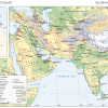
When working with an atlas publisher – whether undertaking the cartographic design of a new atlas from scratch or updating ...

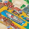
The tourism industry leverages mapping as a powerful tool to promote holiday destinations, local attractions, and in its overall marketing ...

Good map design is an intricate process that involves several stages, from initial concept to final implementation. These stages ensure ...