In providing custom mapping commissions to Publishers for over 50 years, we have also developed skills and capabilities in research and editorial to support clients in the preparation of materials prior to publication. The research and editorial stages in cartography can include ground research and data checking, also updating and checking of place names and other map content through desktop research.
Up until the early 2000’s the lack of easily accessible information meant our research and data capture teams team grew, however, as more and more information became accessible online the basic research has reduced and we are spending more time checking and validating source material.
We currently have a full time team of six people who work on building and modifying map databases, this team works closely with our cartographic team of five people.

Research tasks
We have significant expertise in researching and sourcing content and appropriate data for mapping commissions.
We regularly research basic map content such as town names and population, transport features, tourist information, we also research subject specific information on topics such as climate, history or other topical areas.
We review all potential source material by:
- Verifying the integrity and of the data, for example who compiled it and by what means.
- Check how and when was it last updated
- Completeness of the data
We regularly work with commissioning editors and also authors to identify sources of reliable and up to date information.
Research may be used to add content to mapping, to ensure that information is evenly spread across the area and to ensure consistency across a range of maps. The visual hierarchy of a map, with categorisation of features, can be addressed through editorial research. The use of data sources alone may not be enough to address this, and editorial research is used to enhance the map content and categorisation.
Editorial Checking
Mapping requires constant updating to ensure that detail is current and appropriate. Politically, countries and cities may change names, and this must be reflected on maps. World, continental and country maps are updated as soon as new major changes occur, and should be periodically checked for changes to settlement populations and other features.
Larger scale maps are editorially checked on a regular basis for new road construction, currency of points of interest, new housing estates, etc.
Copyright clearance and accreditation
We can also assist with securing the rights to use third party datasets and images and adding any accreditations or copyright lines. Our editorial staff have experience in handling Intellectual Property clearance and in requesting permissions for use proprietary datasets.
Editorial selection and attribution skills
Information can be portrayed in many different ways, for example to highlight a point or trend in the data or perhaps to skew the information to back-up a particular view point.
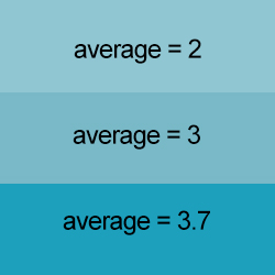
Here is an example of values arranged in a grid:

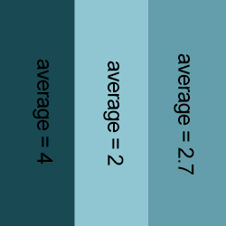
The same grid can displayed in different ways by combining values
 Or in another way

We have a lot of experience in looking at data and establishing the best way to illustrate a point or argument.
Over the last 50 years we have mapped so many topics, from Atlases of Historic Towns to global asteroid strikes, but we are always interested in new topics and looking at how best to present them on a map.


