A brief history of Lovell Johns
1963-65

The beginnings of the business came from a requirement for cartographic expertise on behalf of a group of academics from Oxford University, engaged in an international programme to research and create historic towns atlases. This group, the Historic Towns Trust, approached Oxford University Press (OUP) for help in creating their atlases, who in turn recommended experienced cartographer Colonel Henry Johns and hence Lovell Johns was formed – with the sole purpose of drawing maps for the Historic Towns Atlases.
1969
Lovell Johns’ first maps were published in the form of the Historic Towns Trust first atlas, containing a series of UK town plans.
Early ’70s
In the early 1970s the business began to broaden their client base by undertaking cartographic commissions for other publishers, including Macmillan and Oxford University Press. Lovell Johns also set up new offices in Cowley, Oxford.
Early ‘80s
In 1982 Ben Hill and Angela Oliver bought Lovell Johns from Colonel Johns and so became joint owners.
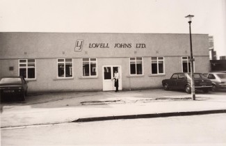
1988
The business moved from Cowley to new, purpose-built offices in Long Hanborough.
1991-92
Lovell Johns bought their first computer, Image Mapper. A very expensive system at the time, based on Intergraph MicroStation, it was purchased to help with production of the London Tube map for Transport for London. The business also invested in its’ first Apple Macintosh computer.
1993–94

Seeking further growth, the business began working with Swedish publisher Maps International who had a distinctive style of political and physical maps and atlases. In collaboration with Maps International, Lovell Johns began building a world database, producing a new set of world maps and atlases with distinctive political colouring.
1996

By 1996 the business had bought the rights to this world database, also the products and the Maps International name which was registered as a UK company. Also in this year, Lovell Johns launched its first website.
From this point all map production was done digitally, seeing an end to using film and darkroom equipment.
1997
In this year Lovell Johns produced a Geothermal Atlas for the European Commission – the first of many such thematic atlases for this client.
1999
1999 saw the creation of a new set of street mapping of all major urban areas across the UK for AA Publishing; consisting of 500 titles, 68,000 sq kms total area, 1.7 million streets, 795,000 index entries, involving 120 staff over 7 months.
2000
In 2000 the business was sold to South African PLC Johnnic Holdings.
2002
MapVu was created – a new range of contiguous GB base mapping at 5 different scales – with a view to develop the custom mapping side of the business.
2003-04
The first Maps International website was launched, developed to sell standard map products to the mass market.
Also in this year, the business was awarded a 5-year framework agreement to provide Geographic Information Services (GIS) database services to the European Commission.
2005-06
The business began work on some prestigious projects:
· A world GIS database conversion project for National Geographic
· An International Atlas for National Geographic
· A 1:100,000 scale atlas for AA Publishing
· Concierge Guide maps for InterContinental Hotels Group
2007
In 2007 Lovell Johns sold their first online mapping application to a Local Authority Planning Department – planvu. Today we have 20 clients using the interactive mapping solution.
We also started work on over 400 UK town plans for Yellow Pages.
2010
In 2010 the business launched a new offering for site-centred map products and solutions for business – BusinessMapCentre.
2011
MapVu 50 won the Silver Award for Best Digital Data Product at International Map Industry Association (IMIA) awards.
2013
Lovell Johns were awarded a 3 year contract to design, build and host a web GIS solution for European Commission Directorate-General for Maritime Affairs and Fisheries (DG MARE).
2014
David Stephens and Liz Murray, Managing Director and Sales and Marketing Director respectively, bought the business from its South African owners, becoming joint business owners.
Lovell Johns’ Historic Map of York wins the British Cartographic Society Award for best map.
2015
In recognition of 50 years in business, 14 members of staff undertook the 3 Peaks Challenge in celebration!
2016-17
The European Commission DG MARE web GIS solution contract is renewed for another 2+2 years.
2018-19
The business began work on several exciting projects:
- Production of 50 custom maps for luxury hotel chain Belmond
- Provided cartographic and design support for the World Atlas of Desertification
- Data conversion and design of 2,700 Port Maps for international Shipping Services client
Launched gi Perspective, our GIS consultancy and digital mapping solutions brand
2019-2020
Lovell Johns’ GIS arm gi Perspective, appointed as sub-contractor to specialist software systems provider CGI, was responsible for the digitising of map-based registers for all Common Land and Town and Village Greens throughout Wales.
Our team performed on-site scanning of tens of thousands of legacy paper-based Common Land registers across all 22 Welsh Local Authorities, many of which are decades old and in a fragile condition.
2021
Lovell Johns becomes an Employee Ownership Trust (EOT), meaning the company is now owned (through a trust) by our staff.
gi Perspective were commissioned to create a media asset mapping application for use by the Qatar Government Supreme Committee for Delivery & Legacy (SC) who were responsible for planning and operations for the FIFA World Cup Qatar 2022™.
2023
Lovell Johns is contracted to provide cartographic support to Dorling Kindersley for their Map by Map series of illustrated atlases.
2025
The business celeberated it’s 60th anniversary!