How Wayfinding Maps can benefit Town Centres
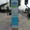
Good wayfinding maps can provide many benefits for town centres because they help people move around easily, improve visitor experience, ...
Good wayfinding maps can provide many benefits for town centres because they help people move around easily, improve visitor experience, ...
When choosing between 2D and 3D cartographic design for any project, there are number of factors we usually discuss with ...
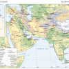
When working with an atlas publisher – whether undertaking the cartographic design of a new atlas from scratch or updating ...

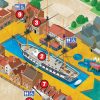
The tourism industry leverages mapping as a powerful tool to promote holiday destinations, local attractions, and in its overall marketing ...