
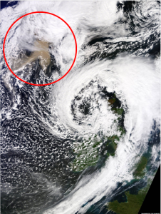
 This image, by NASA’s Terra satellite and published by Dundee University’s Satellite Receiving Station. The ash cloud (circled in red) is clearly visible moving in the direction of the UK.
While British Airways and Ryanair attack airspace closures, claiming their planes have gone through no-fly zones without incident, thanks to Nasa”s Terra satellite we are able to see what all the fuss is about.
The pink-coloured ash, in the top left of the picture, was taken by Nasa”s Terra satellite on Monday afternoon and was published by Dundee University”s Satellite Receiving Station.
For a larger view of the image visit http://www.bbc.co.uk/news/uk-scotland-13519331




Comments are closed here.