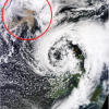
Icelandic ash cloud from space
This image, by NASA’s Terra satellite and published by Dundee University’s Satellite Receiving Station. The ash cloud (circled in red) ...
This image, by NASA’s Terra satellite and published by Dundee University’s Satellite Receiving Station. The ash cloud (circled in red) ...
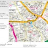
Since our last MAPit Public Sector, the Ordnance Survey has now officially released a series of map datasets covering the ...
Last year Lovell Johns became Philip’s exclusive reseller of their map data. Through our online brand mapsinternational.co.uk we started offering ...
We have been appointed as sole resellers for all Philip’s map data. Philip’s mapping data is one of the most ...