
Lovell Johns New Website Launched
We did it! After months of planning and hard work, we launched the completely redesigned Lovell Johns website on August ...
We did it! After months of planning and hard work, we launched the completely redesigned Lovell Johns website on August ...
Maps International is pleased to announce the launch and sale of our London Map Guide for Kindle. As one of ...

You may have read an earlier blog post about how the current Tube Map confuses 30% of passengers into ...
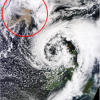
This image, by NASA’s Terra satellite and published by Dundee University’s Satellite Receiving Station. The ash cloud (circled in red) ...