Lovell Johns works with a variety of publishers to provide mapping services, from the largest and most familiar names, through smaller travel writers, to individuals looking to self-publish. All of them have a common goal – to add clear and concise mapping content and cartographic design, to support their written text. All require good value for money, attention to detail and adherence to a print schedule.
We use data rulebases to set the map styles, exporting from GIS software to an editable format to be further developed by our cartographic team. We have access to many different datasets, often using a mixture of several sources to achieve the correct level of detail required. We also offer editorial services if required, supplementing data sources or researching a particular historic period. Maps are then tidied and additional information added, perhaps supplementary points not included in the original data or the inclusion of a legend or scalebar.
Large Publishers
Amongst the larger publishers Lovell Johns have worked with over the years are household names such as Harper Collins, Hachette, Doring Kindersley, Philip’s and Penguin Random House. These publishers tend to approach us with a well-defined set of specifications to ensure a consistent design throughout a publication.
The consistency of style and detail is the key element. They may require a set of maps for one publication, or perhaps several maps across a range of books, each needing to be clearly identifiable with their house design. Lovell Johns can create individual custom maps, or a seamless styled base for extraction and editing by the publisher’s own design team.
We even developed a bespoke web portal for travel publisher Cicerone to help their authors scope their own mapping areas. Routes can be uploaded to the portal and map extracts exported and styled with a pre-defined specification. This ensures that the exact coverage is exported, and that each map can be styled the same. Maps are exported in to Adobe Illustrator format, which can be edited further if required to make a completely unique product. Editable files are then supplied to Cicerone for further work by their design team or writer.
Smaller and industry-specific Publishers
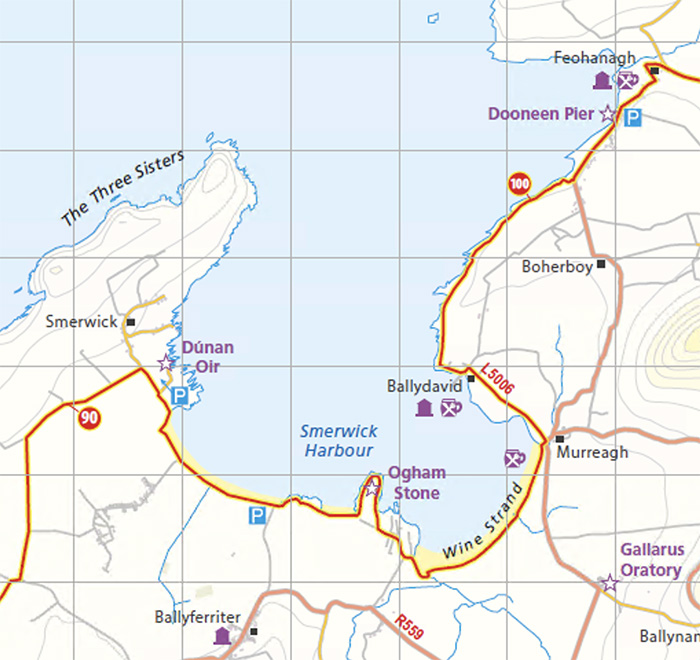
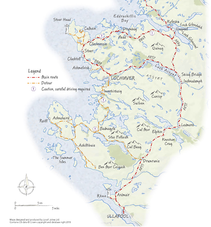
Some smaller publishers may be happy for a completely new design to match each subject matter; Birlinn approached Lovell Johns to create mapping for their ‘North Coast Journey’ book, showing travel routes around northern Scotland. They wanted a hand-drawn, relaxed style, and Lovell Johns made suggestions, with a few samples of mapping to help them define the look they wanted.
Self-publishers and individual projects
Recent times have seen an increase in our mapping services for self-published authors. There may be a requirement only for one or two maps for a single project, but Lovell Johns are available to guide an author through the process and offer advice on styles and content, etc. Value for money is particularly important in this case, as well as the expertise and support we can offer.
For more than 50 years, Lovell Johns have worked with publishers large and small to help them bring good cartography into their books, guides and websites. We have built relationships with many well-established publishers but also a host of smaller individual concerns, all of whom have benefitted from the inclusion of clear and informative mapping in their publications.
Comments are closed here.