Mapping companies face a continuous challenge
At a local level, while new maps are being printed or uploaded onto a website, street names change, new housing estates spring up and bypasses are built. On a global level, natural disasters such as landslides affect real world topography and its not that uncommon for a country or regional border to be redrawn as a result of changes in naming convention.
Changing the world
When updating our world maps the editorial process is significant, involving checking alternative trusted sources for changes in population size, changes to city names as well as aspects of topographic detail shown on the mapping. The update process is firstly applied to the most detailed map in the series and then cascaded down to smaller scales and formats.
In order to support our range of world and continental wall maps, mapping companies like Lovell Johns are alerted to geographic changes so we can update our files.
For example, the Czech Republic recently changed its name to the more popular form of Czechia, which affected some 80 different versions of our world map, at various scales and in different languages and formats. Fortunately on this occasion this change coincided with our planned annual editorial updates, so could be addressed at the same time.
Road layouts and country flags
In the production of road atlases mapping companies like us are always working to a future publication date, with a cut-off for including new features such as new road schemes. This approach ensures that when an atlas is printed the road layout will be future-proof for a certain period of time and will be ‘current’ when it becomes available in the shops. These processes involve checking with relevant Local Authorities and construction companies for the latest available information.
As well as maps, Lovell Johns also maintains and licenses a database of world flags which in turn requires careful monitoring and updating to reflect the latest standards. Although changes to flags are infrequent, it is politically important to keep such a database up to date.
Choosing not to update maps
Of course some changes in the real world can be ignored by mapping companies as in reality they will have minimal impact on a maps’ practical uses and therefore may not adversely affect it; for example, changes to a town street name or a new road junction are of no importance for a regional level map.
From a financial perspective, it is also impractical to reprint editorial maps every time a change occurs and the decision on whether to reprint or not will also depend on the popularity of a map, the amount of stock still held as well as the requirements of the end user.

For specific printed maps such as aeronautical or marine charts, where omission of a major change may place lives at risk, updates and changes may be issued to the user through an online service. This works particularly well for changes to text or for an image patch to ‘stick over’ a particular area.
Updating digital maps
Fundamentally, the digital map has an advantage over the printed map when it comes to editorial updates; it is a relatively simple task for a mapping company to make a minor change and upload a new PDF. In the case of online maps, a programmer can potentially update and refresh a map for new content in a matter of minutes.
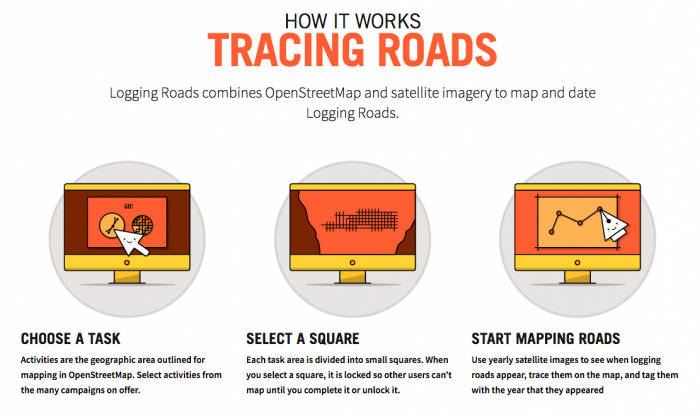
For organisations without vast budgets but seeking to publish detailed and complex geographic information, the use of crowd sourced information means that highly detailed disparate changes can be provided by motivated volunteers then ‘qualified’ by a cartographer and a new editorial map republished.
Anyone consulting a recently published map or atlas will reasonably expect it to contain the latest geographic information. In the map making world it is the bane of the cartographer’s life when such things happen – it can be guaranteed that as soon as a map is published, we will receive notification of a change!
Comments are closed here.